Sault Ste. Marie in 1836: The Fur Trading Outpost
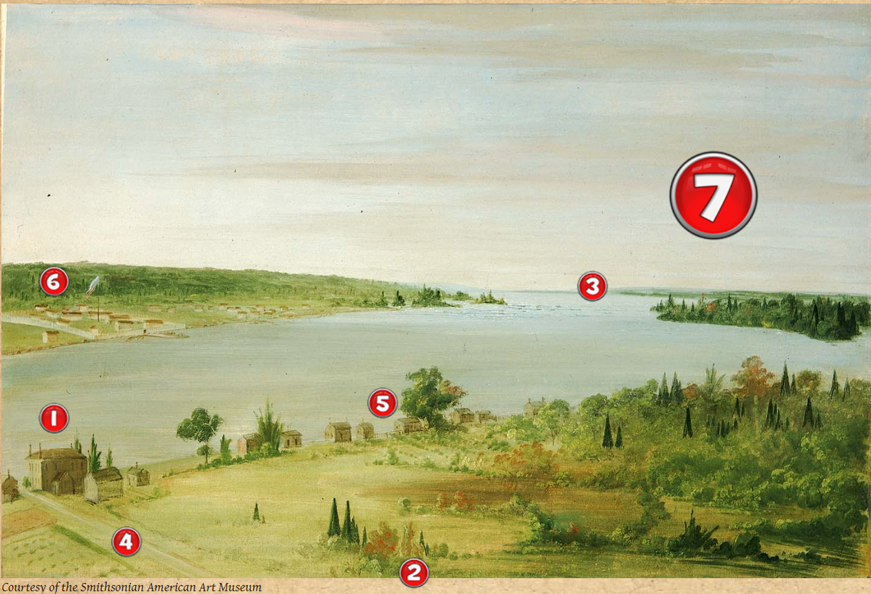
Number 1

Courtesy of the Smithsonian American Art Museum
This is the only building in the painting that is still standing.
Do you know its name?
Do you know who built it?
When it was built?

This is the Old Stone House.
It was built by the fur trader Charles Oakes Ermatinger in 1814.
He and his Anishinaabe wife Mananowe lived there for 14 years until they moved to Montreal
Number 2

Where do you suppose George Catling sat to paint this picture?
 George Catling probably sat where the red arrow is pointing, at the top of the hill where Pim St. is today. We see places like Sault Ste. Marie today with the help of airplanes and satellites above the earth. It's quite a different way of seeing! Compare the two pictures.
What do you see that was not there in 1836?
What is the yellow arrow pointing to?
Would you rather live in 1836 Sault Ste. Marie or today? Why?
Number 3

This is what the Sault rapids looked like in 1836. What has changed since then?
What items have been added to the picture?
A Bridge for Cars and Trucks
 This picture is of the Sault Ste. Marie International Bridge being built in 1962.
In 1962 a bridge was built between Sault Ste. Marie, Canada and Sault Ste. Marie, Michigan. Before that you had to take a ferryboat if you wanted to cross the river! Why would people want a bridge instead of a nice boat ride to go from one Sault to the other?
Power from the Water
 Picture of the Lake Superior Power Company around 1894
In 1875 the first hydroelectric power dam was built at the Sault. This meant that the water from the rapids (hydro) could be used to create power (electricity), although back then there wasn't much to plug in! Today the hydroelectric power dam at the Sault uses that same water flow to make power for all the electricity used by people in the Sault. What do you think used electricity in the Sault in 1875? What do you or your family use each day that needs electricity today? What wouldn't you be able to do today if there was no electricity? Thanks Sault rapids!
Locks for Shipping
 Upper Entrance, Sault Ste. Marie Canal
Up until 1855 when the first lock was built there was no way to get ships full of goods through the Sault Ste. Marie rapids. The difference in height between lake Superior and St. Mary's river made trying to sail it like a wild roller coaster ride with no safety straps for the sailors!
Before the locks were there, the only people who would dare go through the rapids were First Nations and Métis who knew exactly where their canoe could safely go. Below is a picture of a canoe shooting the rapids in 1909.

When a ship enters one of the locks it is "locked up" between St. Mary's River and Lake Superior and water is pumped in or let out until it is safe for the ship to sail on. Today there are four American locks and one Canadian lock where the rapids used to be.
Once ships could sail from St. Mary's river to lake Superior, the locks became very popular
 Courtesy Norm Tufford, greatlakes-seaway.com
Research Questions:
What is the difference in water level between lake Superior and St. Mary's river?
How is the water pumped in or let out of the locks?
Why is there a difference between the water level of lake Superior and St. Mary's river?
Before the locks were there, how did people get goods from St. Mary's river to lake Superior?
How long did it take to build the locks? How many workers did it take?
Why did the Canadians build their lock in 1875?
Number 4

What do you see in the field beside the old stone house?

These are farming crops. The fur trader Charles Ermatinger was the first European to plant crops in Sault Ste. Marie. What do you think he grew there?
Do you know anyone with a farm or a garden?
What do they grow?
Number 5
 How many houses can you count along the shore?
How many people would you guess lived here in 1836?
There are about seven little houses along the shore. In his study of the Robinson-Huron Treaty, James Morrison said that in 1847, (about ten years after this painting was made), there were fifty families, about 250 people altogether living on the British side of the river. For centuries before this, meanwhile, hundreds of First Nations people would gather at Bawating, (the Sault), in the summertime, partly because the river was thick with whitefish so there was plenty to eat for everyone! Chief Dean Sayers of Batchewana First Nations has said that the elders tell him that in those days you could walk from one side of the river to the other on the backs of the whitefish. Now that's a great way of saying there were a lot of fish!
How many people live in Sault Ste. Marie today?
Number 6

What is that fort?

This is Fort Brady. It was built in 1820 by the American Government when Governor Lewis Cass came to claim Sault Ste. Marie as part of Michigan territory. There was quite a ruckus when one Ojibway warrior whose brother had been killed by American soldiers, refused to let the American flag fly and wanted to fight. Two Anishinaabe leaders, Susan Johnston and Shingwaukonse, convinced the warrior to put aside his weapons, avoiding a battle where many would have been killed.
What would you have done?
Number 7
Now look at the painting again without all those numbers.
How many of the things you learned about can you remember?
What did you learn about the house, where the painter sat, the rapids, the field beside the house, the fort?
